In the realm of aerial imaging and geographic data acquisition, the utilisation of drones has brought about a seismic shift in the way we perceive and interact with our surroundings. Among the many applications of drones, 3D drone mapping stands as a remarkable testament to the fusion of cutting-edge technology and precision data capture. UAS Imagery pride ourselves on exploring its significance, applications, and the transformative impact it has had on various industries.
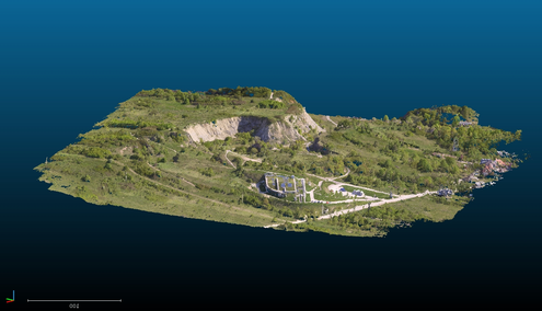
3D drone mapping, in its essence, is the process of creating three-dimensional representations of landscapes, structures, or objects from captured aerial imagery using unmanned aerial systems (UAS), commonly known as drones. Unlike traditional mapping methods, which rely on 2D representations, 3D mapping provides a comprehensive and immersive view of the terrain or subject being studied.
The magic lies in the combination of state-of-the-art hardware and software. Drones equipped with high-resolution cameras, LiDAR (Light Detection and Ranging) sensors, and GPS technology capture detailed aerial imagery and location data. This data is then processed using specialised software to create accurate 3D models. The fusion of imagery and LiDAR data allows for the creation of highly detailed and precise 3D reconstructions.
In the ever-evolving field of 3D drone mapping, several exciting trends and innovations are worth noting. One such trend is the integration of artificial intelligence (AI) and machine learning algorithms. These technologies enable drones to autonomously identify and analyse objects and terrain features, further enhancing the speed and accuracy of data processing.
Furthermore, the miniaturisation of LiDAR sensors and the development of more compact and agile drones have expanded the accessibility of 3D mapping technology. This allows for mapping in challenging environments like dense forests or urban canyons.
Additionally, the use of multispectral and hyperspectral sensors on drones has unlocked new possibilities in applications such as environmental monitoring and precision agriculture. These sensors can capture data beyond what the human eye can perceive, providing valuable insights into vegetation health and resource management.
As drone technology continues to advance, we can expect to see even more innovative applications and increased integration across various industries. From disaster response and archaeological exploration to virtual reality and augmented reality experiences, the future of 3D drone mapping holds immense potential for reshaping how we interact with our world.
Surveying and Mapping: 3D drone mapping has revolutionised land surveying and cartography. It enables professionals to create highly accurate topographic maps, aiding in urban planning, infrastructure development, and environmental monitoring.
Construction and Architecture: Architects and construction companies employ 3D drone mapping to monitor construction progress, detect discrepancies, and visualise the finished structure before it’s built. This technology enhances project management and minimises errors.
Agriculture: Precision agriculture benefits from 3D drone mapping by providing insights into crop health, soil composition, and irrigation needs. Farmers can optimise their operations, leading to increased yields and reduced resource usage.
Mining and Resource Management: The mining industry utilises 3D drone mapping to assess the topography of mining sites, monitor stockpiles, and plan extraction strategies. This leads to more efficient resource management and reduced environmental impact.
Environmental Conservation: Conservationists use 3D mapping to monitor changes in ecosystems, track wildlife migrations, and assess the impact of climate change. This data aids in better decision-making for preserving our natural world.
Infrastructure Inspection: 3D drone mapping is used for inspecting critical infrastructure such as bridges, dams, and power lines. It allows for early detection of structural issues, reducing the risk of accidents.
Cost-Efficiency: Compared to traditional surveying methods, 3D drone mapping is more cost-effective, as it reduces the need for on-site personnel and equipment.
Speed and Efficiency: Drones can cover large areas quickly, expediting data collection and analysis.
Safety: The use of drones eliminates the need for workers to access hazardous or remote locations, enhancing safety on job sites.
Accuracy: High-quality data results in more accurate 3D models, which are crucial for decision-making and planning.
Data-rich Insights: The detailed 3D models provide insights not achievable with 2D data, improving decision-making processes.
While 3D drone mapping has shown remarkable potential, it is not without challenges. These include regulatory hurdles, data security concerns, and the need for skilled operators. Nevertheless, the future holds promising developments such as increased automation, improved AI-based analysis, and enhanced drone capabilities.