
Introduction
Ground Control Points (GCPs) are essential elements in the business of photogrammetry and geospatial analysis. They serve as anchor points that tie photogrammetric data to real-world coordinates, ensuring accuracy and reliability in mapping and surveying projects. This article will dive into what GCPs are, their importance, their role in enhancing the accuracy of maps and practical considerations for their implementation, including their use in conjunction with RTK and PPK technologies.
What are Ground Control Points?
Ground Control Points are specific locations on the Earth’s surface with known geographic location, marked clearly on the ground and used as reference points in photogrammetry and remote sensing. These points enable the accurate transformation of photogrammetric data from image space into real-world coordinates.
Why Use Ground Control Points in Photogrammetry?
Photogrammetry involves capturing images from aerial platforms, such as drones or aircraft, and stitching these images together to create maps or 3D models. Without GCPs, this process can lead to significant inaccuracies due to distortions caused by camera tilt, terrain variations, and other factors. GCPs provide a means to correct these distortions, ensuring that the final output is geographically accurate and reliable.
Importance of Ground Control Points
The primary function of GCPs is to improve the spatial accuracy of maps and models. By referencing known coordinates, photogrammetric software can correct image anomalies and align the data with real-world positions. This alignment is crucial for applications requiring high precision, such as cadastral mapping, infrastructure development, and environmental monitoring.
GCPs also play a vital role in integrating photogrammetric data with other geospatial datasets. For instance, combining aerial imagery with GIS data or LiDAR scans necessitates a common reference framework, which GCPs provide.
In many jurisdictions, accurate mapping and surveying are not just a matter of precision but also a legal requirement. GCPs ensure compliance with these standards, providing verifiable accuracy that can be critical in legal disputes, land transactions, and regulatory approvals.
Ground Control Point Characteristics
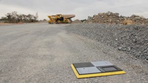
GCPs should be clearly visible in aerial imagery, which means their physical size and colour are crucial considerations. Typically, GCPs are designed as cross-shaped markers, with arms extending 50-100 cm. The optimal size may vary depending on the flight altitude and camera resolution. Additionally, a mark to identify the specific ground control point should be visible. e.g. a number.
High-contrast colours are essential for visibility. Black and white combinations are commonly used, as they stand out against most natural backgrounds. In some environments, bright colours like orange or yellow may be preferred to ensure contrast.
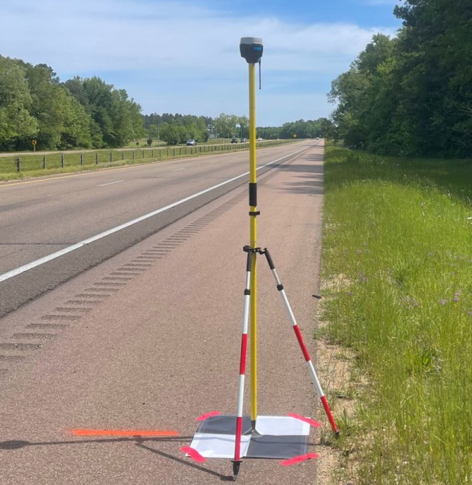
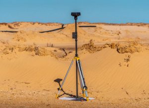
Measuring the Position of a Ground Control Point
Accurate positioning of GCPs is achieved using high-precision GPS equipment. There are several methods to determine the coordinates of GCPs:
DGPS enhances the accuracy of standard GPS by using a network of fixed ground-based reference stations. These stations broadcast correction signals, improving positional accuracy to within a few centimeters.
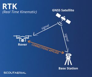
RTK and PPK are advanced GPS techniques that provide even higher accuracy. RTK uses real-time corrections from a base station to a rover (the GPS unit at the GCP), while PPK involves collecting GPS data and processing it after the survey. Both methods can achieve centimeter-level accuracy, making them ideal for GCP positioning.
GCPs in RTK and PPK Surveys
In RTK surveys, a base station is set up at a known location, and a rover unit is used to survey GCPs. The base station transmits correction signals to the rover, allowing real-time adjustments and high positional accuracy. This method is efficient and suitable for dynamic surveying conditions.
PPK surveys are similar but differ in the timing of data correction. Instead of real-time adjustments, GPS data from the base station and rover are recorded and later processed to apply corrections. PPK is advantageous in areas with poor real-time signal transmission, ensuring accuracy through post-processing.
Relative Accuracy vs. Absolute Accuracy
In geospatial terminology, accuracy is categorized into relative and absolute accuracy:
Relative accuracy refers to the consistency of measurements within a dataset. In photogrammetry, it ensures that the relative positions of objects are correct, even if the entire dataset is shifted from its true position. High relative accuracy is crucial for internal consistency within a project.
Absolute accuracy, on the other hand, is the accuracy of the dataset relative to real-world coordinates. It ensures that the photogrammetric data aligns correctly with global positioning systems, providing true-to-life representations. GCPs are vital for achieving high absolute accuracy.
Determining the Number of Ground Control Points
The number of GCPs required for a project depends on several factors, including the size of the survey area, the terrain complexity, and the desired accuracy. Generally, more GCPs result in higher accuracy but also increase the time and cost of the survey.
General Guidelines
- Small Areas: For small survey areas, 4-5 GCPs may be sufficient.
- Medium Areas: Medium-sized projects typically require 6-10 GCPs.
- Large Areas: For large or complex areas, 10-20 GCPs or more may be needed.
Spacing Ground Control Points
The spacing of GCPs should ensure comprehensive coverage of the survey area and account for terrain variations. A common practice is to place GCPs at regular intervals, with additional points at critical locations such as corners, edges, and elevation changes.
Typical Spacing
- Flat Terrain: In flat terrain, GCPs can be spaced 500-1000 meters apart.
- Hilly Terrain: In hilly or complex terrain, spacing may be reduced to 200-500 meters to capture elevation changes accurately.
Using Ground Control Points and Checkpoints Together
Checkpoints are additional reference points used to validate the accuracy of the photogrammetric model independently of the GCPs. While GCPs are used to align the model, checkpoints are used to assess its accuracy.
Difference Between GCPs and Checkpoints
- GCPs: Used to control and adjust the photogrammetric model.
- Checkpoints: Used to verify the accuracy of the model after processing.
In practice, a combination of GCPs and checkpoints ensures both alignment and validation, providing a robust accuracy assessment.
Base Stations
Base stations are critical components in RTK and PPK surveys. They serve as the reference point for transmitting correction signals to rover units.
Key Considerations for Base Stations
- Location: Should be placed at a known, stable location with clear sky visibility.
- Accuracy: Must be precisely positioned using high-accuracy GPS equipment.
- Communication: Should have reliable communication with rover units, either through direct radio signals (RTK) or recorded data (PPK).
Suppliers of Ground Control Points
Several suppliers specialize in providing GCP equipment and related services. Some notable ones include:
- Propeller Aero: Offers a range of GCP kits designed for drone surveying.
- DJI: Offers GCP kits compatible with their drone systems.
Conclusion
Ground Control Points are indispensable in the field of photogrammetry, ensuring the accuracy and reliability of geospatial data. By understanding their importance, proper implementation, and the role they play in conjunction with advanced GPS technologies like RTK and PPK, surveyors can achieve high precision in their projects. Whether for small-scale surveys or extensive mapping projects, the strategic use of GCPs lays the foundation for accurate and dependable geospatial analysis. Contact us now to see how you can gain more accurate insights into your business!