
SURVEYING USING DRONES: HISTORY
Over the last decade there has been plenty of talk about the uses and benefits of using UAVs (more widely known as drones) within various commercial sectors. Before we delve into the plethora of possibilities for using this paradigm shifting technology, it is important to understand the differences between some terms that are used within this space.
The military were originally the first to utilise pilotless airframes. This is where the term “drone” comes from. A drone is an unmanned aircraft (or ship) capable of autonomously navigating without human input. These drones generally conducted reconnaissance or bombing missions, however, today it seems this term has now become a blanket description for what we now see being used for commercial and retail applications.
Towards the mid 1980s the term UAV emerged. This is an acronym for unmanned aircraft (or aerial) vehicle. A UAV is a little more of a generalised term. It refers to not only a drone but also a remotely piloted vehicle, the difference being a pilot (on the ground) controlling the aircraft remotely as opposed to a fully autonomous drone.
So now that we understand what we are actually talking about, how can we utilise and benefit from these machines within our businesses?
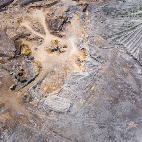
 STOCKPILE CALCULATIONS
Once upon a time, conventional surveying measurements of stockpile volumes was a somewhat precarious task. It meant climbing over the pile with GPS equipment and taking coordinates from several locations. This method was far from accurate nor was it an efficient use of a surveyors time. In addition to this the safety aspect was far from ideal.
This method usually meant gathering data over the course of a few days. Then it was a matter of crunching numbers to come up with a final figure and then compiling the report. In many cases, this process could take up to a week or more.
Surveying using drones has changed this process and can now be completed in a matter of hours. Once the flight plan has been created, the task is completed autonomously from take-off to landing via autopilot controlling software running from a tablet or laptop. The images are take autonomously via the same software and stored on an SD card housed on the drone.
These images are then downloaded and analysed by state of the art imaging software to produce point clouds. Stockpile volume measurements can then be derived using this software with the click of a mouse. All in a fraction of the time of conventional methods.
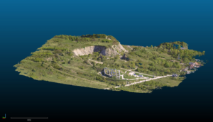
MAPPING
One other such use for drones within mining is the ability for us to map any given area. Open cut mines are continually changing and the use of drones to take aerial images to create maps, 3D models, digital terrain maps (DTM) and digital surface models (DSM) has changed the way mines monitor their operations. These derivatives can be particularly useful pre and post blasting ensuring the objectives were completed. In addition to the comparison, it also gives a completely up to date model allowing personnel to track change over time.
Images taken by drones also allow assessment of infrastructure. Road maintenance requirements, water drainage, storm damage and environmental protection applications are all possible using drones for aerial surveying.
 ASSET INSPECTION
Undoubtedly, one of the most useful applications for surveying using drones within the mining sector is for asset inspection. This, historically is a dangerous, time consuming and expensive task, often requiring specially trained people suspended at heights to visually inspect equipment.
Drones have eliminated almost completely these hazards and made the task more efficient, both in time and financially. Under some circumstances, safety is further increased with the drones take-off and landing phases being conducted off site in a separate location.
Using high definition lenses these airborne cameras can photograph equipment such as a nut or bolt from up to 50 metres away and still produce a resolution that shows the tiniest details.
ENHANCED ACCURACY AND EFFICIENCY
Traditional surveying methods often entail labor-intensive processes and time-consuming procedures, which may not always guarantee precision and accuracy. In contrast, drones equipped with advanced imaging systems, such as LiDAR (Light Detection and Ranging) and/or photogrammetry, enable rapid and precise data collection with unparalleled accuracy. These UAVs can swiftly navigate over rugged terrain, capturing detailed images and generating 3D models of the mine site with remarkable precision. This enables engineers to obtain real-time insights into the topography, geological structures, and potential hazards of the site, facilitating informed decisionwhat is -making and efficient resource allocation.
SAFETY FIRST: MINIMISING RISK FOR PERSONNEL
Safety is paramount in the mining industry, where workers often face hazardous conditions and environments. Surveying using drones allows mining companies to significantly mitigate risks to personnel by minimizing the need for manual inspections in dangerous areas. Instead of sending workers into potentially perilous zones, drones can autonomously navigate through confined spaces, steep slopes, and unstable terrain, capturing vital data without jeopardizing human lives. This not only enhances safety protocols but also enhances operational efficiency by reducing downtime associated with safety concerns.
COST EFFECTIVE SOLUTIONS
In addition to their accuracy and safety benefits, drones offer cost-effective solutions for mine surveying operations. Traditional surveying methods often involve substantial manpower, equipment, and logistical expenses. Conversely, drones require minimal human intervention and can cover large areas in a fraction of the time, resulting in significant cost savings for mining companies. Moreover, the data collected by drones can be analysed using sophisticated software tools, allowing for efficient resource management and optimisation of mining processes. By streamlining surveying operations and reducing overhead costs, drones prove to be a valuable asset for enhancing the overall profitability of open cut mines.
ENVIRONMENTAL CONSERVATION AND SUSTAINABILITY
Beyond their operational advantages, surveying using drones plays a crucial role in promoting environmental conservation and sustainability within the mining sector. By conducting aerial surveys, drones can monitor environmental impacts, assess vegetation coverage, and detect potential areas of erosion or habitat disturbance. This enables mining companies to implement proactive measures to minimize environmental degradation and adhere to regulatory compliance standards. Furthermore, the data collected by drones can facilitate the development of sustainable land reclamation strategies, ensuring that mined areas are rehabilitated and restored to their natural state post-extraction.
WHAT DOES THE FUTURE HOLD?
Technology is ever changing and improving in the aerial surveying realm. Drones are becoming quieter, faster, smarter and carrying cameras that produce ultra high definition images and videos. Applications within mining are limited only by your imagination. In any case, drones are changing the way mines operate. They are saving companies massive amounts of money and time, all while increasing safety and producing accurate high quality outputs that are hurling mines into the age of innovation.
UAS Imagery is a leading aerial surveying and data capture provider. Contact us now to have a solution tailored to your sites needs.